ROS Resources: Documentation | Support | Discussion Forum | Index | Service Status | ros @ Robotics Stack Exchange
Ask Your Question
1

Local costmap static without any sensor information [closed]

asked 2016-05-10 04:21:49 -0500

sosuhui gravatar image

updated 2016-10-24 09:08:06 -0500

ngrennan gravatar image

I am relatively new to ROS and don't have much experience it will be a great help if someone can answer my quetsion.

I am trying to move a robot around using a static map. The global path plannig is correct but it is not showing local costmap (not considering obstacles). I am not using any laser scanner but Kinect Fusion with a Kinect to creating the map and for pose estimation. Is it possible to inflate obstacles without use of any kind of sensor data.

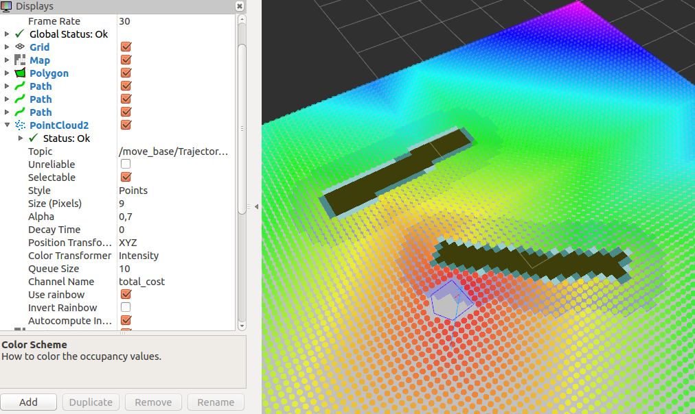
In the screenshot of rviz you can see that the positions near the obstacles have low costs in the local costmap. Due to this the robot will move in the direction of the obstacle.

costmap configuration:

local_costmap:
  global_frame: odom
  robot_base_frame: base_link
  update_frequency: 3.0
  publish_frequency: 2.0
  static_map: true
  robot_footprint: [[0.13, 0.235], [-0.22, 0.235], [-0.35, 0.0], [-0.22, -0.235], [0.13, -0.235]]
  rolling_window: false
  width: 6.0
  height: 6.0
  resolution: 0.1

Global costmap:
  global_frame: /map
  robot_base_frame: base_link
  update_frequency: 5.0
  static_map: true

costmap_common_param
  obstacle_range: 2.5
  raytrace_range: 3.0
  footprint: [[0.13, 0.235], [-0.22, 0.235], [-0.35, 0.0], [-0.22, -0.235], [0.13, -0.235]]
  #robot_radius: ir_of_robot
  inflation_radius: 0.55
  transform_tolerance: 1.0
edit retag flag offensive reopen merge delete

Closed for the following reason the question is answered, right answer was accepted by sosuhui
close date 2016-06-03 05:58:20.935873

Comments

Please post your costmap configurations by editing your question. Please put the configurations into a preformatted text (using the buttons with 101010 on it).

mgruhler gravatar image mgruhler  ( 2016-05-10 04:33:34 -0500 )edit

2 Answers

Sort by ยป oldest newest most voted
0

answered 2016-05-24 05:39:33 -0500

sosuhui gravatar image

updated 2016-05-24 05:40:05 -0500

I finally figured out how to avoid obstacles in local planner while setting rolling_window: false and static_map: true. You can copy map data in your custom layer and make it available for local planner.

edit flag offensive delete link more
2

answered 2016-05-10 05:13:44 -0500

Jbot gravatar image

updated 2016-05-10 05:14:08 -0500

To enable the inflation in static map, you have to add some plugins in your yaml such as :

   plugins:
     - {name: static_layer,            type: "costmap_2d::StaticLayer"}
     - {name: inflation_layer,         type: "costmap_2d::InflationLayer"}

You can refer to the turtlebot navigation yaml files if you need examples : https://github.com/turtlebot/turtlebot_apps/blob/indigo/turtlebot_navigation/param/global_costmap_params.yaml

edit flag offensive delete link more

Comments

I applied the approach but it is not working. I guess problem is not with plugins.

sosuhui gravatar image sosuhui  ( 2016-05-10 05:56:57 -0500 )edit
1

This is due to the fact that you still use the old parameter layout above. I don't think a combination of old and new will work properly. Otherwise, you would also need to configure the plugins properly.

mgruhler gravatar image mgruhler  ( 2016-05-10 10:44:34 -0500 )edit

@mig I had made changes in my config files. Now these are arranged using plug-ins, but no use. Can you please tell me, is navigation stack able to use static layer: true and rolling window: false and having no observation source set?

sosuhui gravatar image sosuhui  ( 2016-05-17 03:27:49 -0500 )edit

the localcostmap should have rolling_window: true and static_map: false. If you do not specify any observation sources for the local costmap, it is "optimizing" the plan through the non-existing obstacles. I'm not sure if what you want can be done...

mgruhler gravatar image mgruhler  ( 2016-05-17 06:19:27 -0500 )edit

That worked for me. Thanks. I just needed to get information from my created map to have the local costmap with the inflation layer.

torkx gravatar image torkx  ( 2016-05-30 19:47:04 -0500 )edit

Question Tools

3 followers

Stats

Asked: 2016-05-10 04:21:49 -0500

Seen: 1,953 times

Last updated: May 24 '16