create a poor map with lidars
I encountered a problem using the Lidar to create the map. Map is not closed. I am using the Gmapping method.
Does anyone know why this is? Or give me some advice? Thank you!
ROS Resources: Documentation | Support | Discussion Forum | Index | Service Status | Q&A answers.ros.org |
I encountered a problem using the Lidar to create the map. Map is not closed. I am using the Gmapping method.
Does anyone know why this is? Or give me some advice? Thank you!
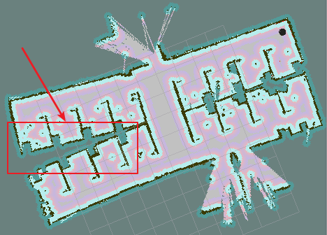
To me it looks like the laser scanner is working well, but the ODOM drift is too high, so the robot loses it's sense of direction over time. Can I assume your robot has wheel encoders? If it does, you should redo the calibration, especially for encoder counts on each wheel during rotating. If your odom is based on a calculation of counts and wheel measurements, I suggest instead you determine the counts/meter and counts/radian through measurement instead of calculating. See section 1.2 of this: http://wiki.ros.org/navigation/Tutori... Once you are confident in the calibration, remap and make sure any rotation during mapping is done very slowly.
Please start posting anonymously - your entry will be published after you log in or create a new account.
Asked: 2017-11-18 09:55:00 -0500
Seen: 110 times
Last updated: Nov 20 '17
How to add SICK TiM Lidar to TurtleBot?
Inaccuracy in 2D map navigation.
ROS amcl Path planning with live gmapping map
Multiple Robotino co-ordination
How to modify the slam_gmapping node on a turtlebot?
How scan angle is measured and published in LaserScan msg?
How do you add new frames to the tf tree of a Jackal robot?
Is it possible to use amcl and slam gmapping at the same time?