ROS Resources: Documentation | Support | Discussion Forum | Index | Service Status | ros @ Robotics Stack Exchange
Ask Your Question
0

gps waypoints are not shown in mapviz

asked 2021-11-05 12:02:27 -0500

Delbina gravatar image

updated 2021-11-06 11:49:23 -0500

hi,

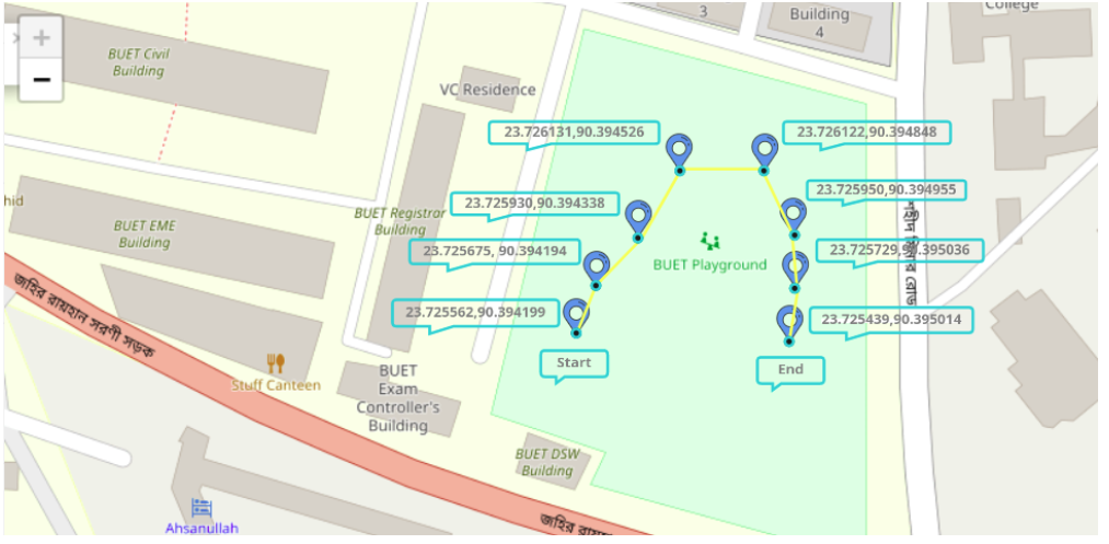
I have followed the procedure in https://github.com/ArghyaChatterjee/g..., in order to be able to see gps waypoints in mapviz, but it doesnot work. I have recorded the gps waypoints, but i do not know how to have those waypoints the same the on which mentioned in the above link.#

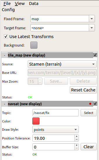
this is message type of my gps::

 rostopic info /gps/fix 
Type: sensor_msgs/NavSatFix

image description

I would be grateful if anybody can support Masoumeh

edit retag flag offensive close merge delete

Comments

Sorry I’m a bit confused. When you say the tutorial link doesn’t work what specifically is not working. What is the error message?

osilva gravatar image osilva  ( 2021-11-05 15:25:45 -0500 )edit

Hi @osilva I mentioned that I followed all the procedures (from installing mapviz to running the bag file) to see GPS waypoints on mapviz, but I cannot see the tagged gps points. It seems there are some other steps to do, but they did not mention them.

Delbina gravatar image Delbina  ( 2021-11-06 04:19:27 -0500 )edit

It looks like you already raised an issue with the developer: https://github.com/ArghyaChatterjee/g...

osilva gravatar image osilva  ( 2021-11-06 05:18:57 -0500 )edit
osilva gravatar image osilva  ( 2021-11-06 05:22:40 -0500 )edit

1 Answer

Sort by » oldest newest most voted
0

answered 2021-11-06 10:24:13 -0500

osilva gravatar image

The Mapviz settings as per medium article:

image description

Notice that: The sequence of plugins in your panel is vital. Because Mapviz draws its plugins in the order that they are listed in the plugin panel. If navsat is listed first, it will draw that first, and then it will draw the tile_map over that, so you would not be able to see any fixes.

Hope this helps resolves the issue.

edit flag offensive delete link more

Comments

Thanks, @osilva, up to this step, everything is fine, I want to have GPS waypoints that are recorded as a goal, be shown in mapviz, i have attached the pic in my question.

Delbina gravatar image Delbina  ( 2021-11-06 11:49:26 -0500 )edit

In the source code, you can see the node subscribes to three topics I think only /outdoor_waypoint_nav/gps/filtered is relevant:

Source code: https://github.com/ArghyaChatterjee/g...

 //Subscribe to topics
    ros::Subscriber sub_gps_raw = n.subscribe("/navsat/fix", 100, raw_gps_CB);
    ros::Subscriber sub_gps_filtered = n.subscribe("/outdoor_waypoint_nav/gps/filtered", 100, filtered_gps_CB);
        ros::Subscriber sub_joy = n.subscribe("/joy_teleop/joy", 100, joy_CB);

I guess you could do the same publish to this topic.

osilva gravatar image osilva  ( 2021-11-06 14:19:27 -0500 )edit

this code only record and save the GPS/ filtered points:

ROS_INFO("You have collected another waypoint cluster!");
ROS_INFO("Press %s button to collect and store another waypoint.", collect_button_sym.c_str());
ROS_INFO("Press %s button to end waypoint collection.", end_button_sym.c_str());

I donot know why the named this file, ploting GPS points!?

Delbina gravatar image Delbina  ( 2021-11-06 15:19:52 -0500 )edit

Take a look at this launch file:

https://github.com/ArghyaChatterjee/g...

You also need to work with parameter server send waypoints.

osilva gravatar image osilva  ( 2021-11-06 15:48:30 -0500 )edit

Question Tools

1 follower

Stats

Asked: 2021-11-05 12:02:27 -0500

Seen: 224 times

Last updated: Nov 06 '21