
How Cartographer publishes Map to base_link transform?
I am using google's cartographer to build a map, but I am unable to understand how it publishes map->base_link transform. I am providing cartographer with imu and velodyne VLP-16 LIDAR data, here is the result of rosbag info:
path:        out2.bag
version:     2.0
duration:    1:19s (79s)
start:       Aug 08 2019 07:25:58.85 (1565229358.85)
end:         Aug 08 2019 07:27:18.42 (1565229438.42)
size:        1.9 GB
messages:    29535
compression: none [1855/1855 chunks]
types:       sensor_msgs/Imu         [6a62c6daae103f4ff57a132d6f95cec2]
             sensor_msgs/PointCloud2 [1158d486dd51d683ce2f1be655c3c181]
topics:      /imu       26871 msgs    : sensor_msgs/Imu
             /points2    2664 msgs    : sensor_msgs/PointCloud2
The issue I am facing is that the robot remains close to its original position and rotates, and sometimes it just shifts its position, the map->base_link transform does not seem to be continuous
Here are .lua and launch files:
include "map_builder.lua"
include "trajectory_builder.lua"

options = {
  map_builder = MAP_BUILDER,
  trajectory_builder = TRAJECTORY_BUILDER,
  map_frame = "map",
  tracking_frame = "imu_link",
  published_frame = "base_link",
  odom_frame = "odom",
  provide_odom_frame = true,
  publish_frame_projected_to_2d = false,
  use_odometry = false,
  use_nav_sat = false,
  use_landmarks = false,
  num_laser_scans = 0,
  num_multi_echo_laser_scans = 0,
  num_subdivisions_per_laser_scan = 1,
  num_point_clouds = 1,
  lookup_transform_timeout_sec = 0.2,
  submap_publish_period_sec = 0.3,
  pose_publish_period_sec = 5e-3,
  trajectory_publish_period_sec = 30e-3,
  rangefinder_sampling_ratio = 1.,
  odometry_sampling_ratio = 1.,
  fixed_frame_pose_sampling_ratio = 1.,
  imu_sampling_ratio = 1.,
  landmarks_sampling_ratio = 1.,
}

TRAJECTORY_BUILDER_3D.num_accumulated_range_data = 100

MAP_BUILDER.use_trajectory_builder_3d = true
MAP_BUILDER.num_background_threads = 7
POSE_GRAPH.optimization_problem.huber_scale = 5e2
POSE_GRAPH.optimize_every_n_nodes = 320
POSE_GRAPH.constraint_builder.sampling_ratio = 0.03
POSE_GRAPH.optimization_problem.ceres_solver_options.max_num_iterations = 10
POSE_GRAPH.constraint_builder.min_score = 0.62
POSE_GRAPH.constraint_builder.global_localization_min_score = 0.66

return options
launch file:
<launch>
  <node name="rviz" pkg="rviz" type="rviz" args="-d $(find nav_stack)/rviz/newCarto.rviz"/>

  <node pkg="robot_state_publisher" type="robot_state_publisher" name="robot_state_publisher"/>
  <param name="robot_description" command="$(find xacro)/xacro '$(find dlive_description)/urdf/dlive_low_poly.xacro'" />

  <node name="cartographer_offline_node" pkg="cartographer_ros"
      type="cartographer_offline_node" args="
          -configuration_directory $(find cartographer_ros)/configuration_files/trials
          -configuration_basenames dlive_offline.lua
          -urdf_filenames $(find cartographer_ros)/urdf/dlive_3d.urdf
          -bag_filenames $(arg bag_filenames)"
      output="screen">

  </node>

  <node name="cartographer_occupancy_grid_node" pkg="cartographer_ros"
      type="cartographer_occupancy_grid_node" args="-resolution 0.05" />
</launch>
Here is the trajectory generated:
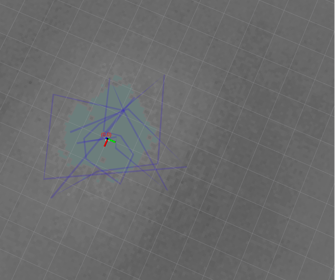
The trajectory should be partitioned rectangles though, also the length of each of these lines is around 1m it should be in 100m
I installed cartographer ros from the official documentation here, and I am running ubuntu 16.04 with ROS kinetic.
If I can understand how map->base_link transform is generated I should be able to understand reason behind the issues I am getting
