ROS Resources: Documentation | Support | Discussion Forum | Index | Service Status | ros @ Robotics Stack Exchange
Ask Your Question
0

How does global and local path finding work in ROS?

asked 2017-10-22 18:30:28 -0500

rozoalex gravatar image

updated 2017-10-23 02:24:57 -0500

gvdhoorn gravatar image

Is there some good resource about how ROS implemented global and local path finding? If I want add some extra sensors which will have the local path finding, what is the best way to do it?

Thanks!

edit retag flag offensive close merge delete

1 Answer

Sort by ยป oldest newest most voted
1

answered 2017-10-22 21:19:51 -0500

Hi rozoalex,

You can find an overview of how the ROS navigation stack works here: http://wiki.ros.org/nav_core?distro=l...

Details of the local planner here: http://wiki.ros.org/base_local_planne...

Details of the global planner here: http://wiki.ros.org/global_planner?di...

This is the basic scheme:
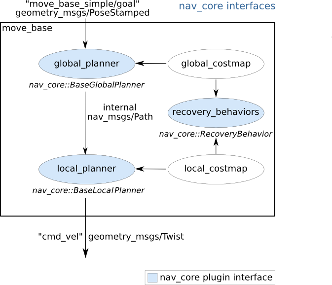
image description

As you can see, both the local planner and the global planner use a costmap (a 2D o 3D representation of free/occupied space) constructed using sensor information.

If you want to add information from new sensors for the local costmap to consider you should do so by adding new layers to the local costmap. The layer type will depend on the sensor type. You should check the tutorials and documentation of the costmap_2d package.

I hope this helps

edit flag offensive delete link more

Comments

Thank you so much! Very helpful!

rozoalex gravatar image rozoalex  ( 2017-10-26 18:52:57 -0500 )edit

Question Tools

1 follower

Stats

Asked: 2017-10-22 18:30:28 -0500

Seen: 247 times

Last updated: Oct 22 '17