ROS Resources: Documentation | Support | Discussion Forum | Index | Service Status | ros @ Robotics Stack Exchange
Ask Your Question
0

Local Planner does not plan through inflated costs?

asked 2013-11-18 23:25:16 -0500

madmax gravatar image

Hi,

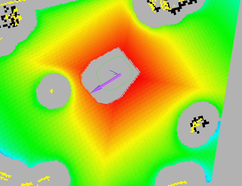
I have a problem with my local planner (base_local_planner).
As you can see on the screenshot, the costmap of the local planner does't take inflated obstacles into account.
But why? Because hitting this inflated area with the side of my robot is possible without having a collision.
Is there some parameter to quickly adjust this behaviour?

Btw: These yellow points in the middle of the grey inflated area are obstacles.

Regards
Max
image description

edit retag flag offensive close merge delete

Comments

Hi Max. A) What distro are you running? B) What is the point cloud/color map in the screenshot showing? (specific topic please)

David Lu gravatar image David Lu  ( 2013-11-19 07:57:47 -0500 )edit

That's a point cloud from the base_local_planner: /move_base/TrajectoryPlannerROS/cost_cloud

madmax gravatar image madmax  ( 2013-11-20 21:07:28 -0500 )edit

What is the red polygon and what is the green polygon?

David Lu gravatar image David Lu  ( 2013-11-21 02:27:03 -0500 )edit

green polygon is the static footprint, red one is dynamic footprint

madmax gravatar image madmax  ( 2013-11-29 22:58:35 -0500 )edit

2 Answers

Sort by ยป oldest newest most voted
1

answered 2013-11-19 10:09:31 -0500

sudhanshu_mittal gravatar image

updated 2013-12-02 01:42:31 -0500

felix k gravatar image

There is ROS package called costmap_2d. The costmap_2d package provides a configurable structure that maintains complete info about all position in the map in the form of a occupancy grid, which helps robot navigate.

Particularly for your problem, there is a parameter called "inflation_radius": default set as 0.55m. I am using ROS fuerte. In my system this parameter is found at: /opt/ros/fuerte/stacks/navigation/costmap_2d/cfg/cpp/costmap_2d/ in Costmap2DConfig.h

For more info, you should refer to the costmap_2d wiki page.

edit flag offensive delete link more

Comments

In detail it is the cost_inscribed parameter.

madmax gravatar image madmax  ( 2013-11-20 21:08:57 -0500 )edit
0

answered 2013-12-01 05:14:38 -0500

David Lu gravatar image

It looks to me like the planner is taking inflated obstacles into account. The lack of colored points around the yellow points indicates that the planner is not even considering driving there.

If you are having problems not indicated in the screenshot (like collisions in planning) then there is a separate problem with the planner.

edit flag offensive delete link more

Question Tools

3 followers

Stats

Asked: 2013-11-18 23:25:16 -0500

Seen: 716 times

Last updated: Dec 02 '13