
The site is read-only. Please transition to use Robotics Stack Exchange
| ROS Resources: Documentation | Support | Discussion Forum | Index | Service Status | ros @ Robotics Stack Exchange |
| | 1 | initial version |
I mapped with hector slam. Using odometry with it, I was able to create this map:
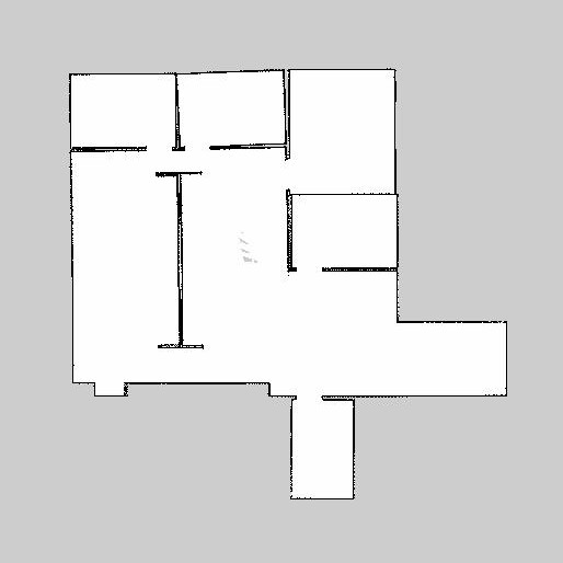
This is pretty close to the original. I don't have the ground truth image, so I cannot make any comparison locally, but, trusting my eyes, it seems to be a pretty good one. Playing with parameters in a launch file, you can probably improve it. Here is the launch file I used to create the above:
<?xml version="1.0"?>

<launch>

  <node pkg="hector_mapping" type="hector_mapping" name="hector_mapping" output="screen">

    <!-- Topic names -->
    <param name="scan_topic" value="base_scan" />

    <!-- Frame names -->
    <param name="base_frame" value="base_laser_link" />
    <param name="odom_frame" value="odom"/>
    <param name="output_timing" value="false"/>

    <!-- Tf use -->
    <param name="use_tf_scan_transformation" value="true"/>
    <param name="use_tf_pose_start_estimate" value="false"/>
    <param name="pub_map_odom_transform" value="true"/>
    <param name="advertise_map_service" value="true"/>

    <!-- Map size / start point -->
    <param name="map_resolution" value="0.050"/>
    <param name="map_size" value="2048"/>
    <param name="map_start_x" value="0.5"/>
    <param name="map_start_y" value="0.5" />
    <param name="map_multi_res_levels" value="2" />

    <!-- Map update parameters -->
    <param name="update_factor_free" value="0.4"/>
    <param name="update_factor_occupied" value="0.9" />
    <param name="map_update_distance_thresh" value="0.4"/>
    <param name="map_update_angle_thresh" value="0.06" />

    <!-- Debug parameters -->
    <!--
      <param name="pub_drawings" value="true"/>
      <param name="pub_debug_output" value="true"/>
    -->
  </node>

  <node pkg="hector_trajectory_server" type="hector_trajectory_server" name="hector_trajectory_server" output="screen">
    <param name="target_frame_name" type="string" value="/map" />
    <param name="source_frame_name" type="string" value="/base_link" />
    <param name="trajectory_update_rate" type="double" value="4" />
    <param name="trajectory_publish_rate" type="double" value="0.25" />
  </node>

  <node pkg="hector_geotiff" type="geotiff_node" name="hector_geotiff_node" output="screen" launch-prefix="nice -n 15">
    <remap from="map" to="/dynamic_map" />
    <param name="map_file_path" type="string" value="$(find hector_geotiff)/maps" />
    <param name="map_file_base_name" type="string" value="hector_slam_map" />
    <param name="geotiff_save_period" type="double" value="10" />
    <param name="draw_background_checkerboard" type="bool" value="true" />
    <param name="draw_free_space_grid" type="bool" value="true" />
  </node>

</launch>
| | 2 | No.2 Revision |
I mapped with hector slam. Using odometry with it, I was able to create this map:
This is pretty close to the original. I don't have the ground truth image, so I cannot make any comparison locally, but, trusting my eyes, it seems to be a pretty good one. Playing with parameters in a launch file, you can probably improve it. Here is the launch file I used to create the above:
<?xml version="1.0"?>

<launch>

  <node pkg="hector_mapping" type="hector_mapping" name="hector_mapping" output="screen">

    <!-- Topic names -->
    <param name="scan_topic" value="base_scan" />

    <!-- Frame names -->
    <param name="base_frame" value="base_laser_link" />
    <param name="odom_frame" value="odom"/>
    <param name="output_timing" value="false"/>

    <!-- Tf use -->
    <param name="use_tf_scan_transformation" value="true"/>
    <param name="use_tf_pose_start_estimate" value="false"/>
    <param name="pub_map_odom_transform" value="true"/>
    <param name="advertise_map_service" value="true"/>

    <!-- Map size / start point -->
    <param name="map_resolution" value="0.050"/>
    <param name="map_size" value="2048"/>
    <param name="map_start_x" value="0.5"/>
    <param name="map_start_y" value="0.5" />
    <param name="map_multi_res_levels" value="2" />

    <!-- Map update parameters -->
    <param name="update_factor_free" value="0.4"/>
    <param name="update_factor_occupied" value="0.9" />
    <param name="map_update_distance_thresh" value="0.4"/>
    <param name="map_update_angle_thresh" value="0.06" />

    <!-- Debug parameters -->
    <!--
      <param name="pub_drawings" value="true"/>
      <param name="pub_debug_output" value="true"/>
    -->
  </node>

  <node pkg="hector_trajectory_server" type="hector_trajectory_server" name="hector_trajectory_server" output="screen">
    <param name="target_frame_name" type="string" value="/map" />
    <param name="source_frame_name" type="string" value="/base_link" />
    <param name="trajectory_update_rate" type="double" value="4" />
    <param name="trajectory_publish_rate" type="double" value="0.25" />
  </node>

  <node pkg="hector_geotiff" type="geotiff_node" name="hector_geotiff_node" output="screen" launch-prefix="nice -n 15">
    <remap from="map" to="/dynamic_map" />
    <param name="map_file_path" type="string" value="$(find hector_geotiff)/maps" />
    <param name="map_file_base_name" type="string" value="hector_slam_map" />
    <param name="geotiff_save_period" type="double" value="10" />
    <param name="draw_background_checkerboard" type="bool" value="true" />
    <param name="draw_free_space_grid" type="bool" value="true" />
  </node>

</launch>
To run the bag in simtime, use this command:
rosbag play <bagfile>.bag --clock
 ROS Answers is licensed under Creative Commons Attribution 3.0 Content on this site is licensed under a Creative Commons Attribution Share Alike 3.0 license.
