ROS Resources: Documentation | Support | Discussion Forum | Index | Service Status | ros @ Robotics Stack Exchange
Ask Your Question
0

Hi everyone, i am new to ROS and i want to make a 3D map using a lidar and a kinect. Is it possible?
asked 2016-01-13 03:36:51 -0500

hashim gravatar image

updated 2016-05-18 07:32:39 -0500

image descriptionhttps://www.youtube.com/watch?v=jgNFe... like the video above, they have used a hokuyo lidar to 2D map the environment using the hector_slam package and then generate an octomap using a kinect sensor i guess. I am not sure how can i do this? lets suppose i have generated the 2D map and octomap separately then how can i combine both like in the video thanks in advance!

edit retag flag offensive close merge delete

1 Answer

Sort by ยป oldest newest most voted
1

answered 2016-01-13 06:28:35 -0500

Well this obviously is possible, because otherwise the video wouldn't be available ;)

The hector_slam setup is following the conventions laid out in the SettingUpForYourRobot tutorial. The octomap is created by feeding Kinect data to a octomap generator node. This part is using tf data generated from SLAM+IMU and essentially performs mapping with known poses.

To reproduce what is shown in your video, you'll want to get SLAM working and have a proper robot model (i.e. have the Kinect mounted correctly on your model and a complete tf tree). Generating the octomap then boils down to feeding the Kinect data to a octomap generator node. The underlying ROS tools (tf, octomap) then will do their magic and create a map.

These slides provide a brief overview.

edit flag offensive delete link more

Comments

Do i need to integrate the IMU and encoder data to get the hector_elevation, octomap working ?

hashim gravatar image hashim  ( 2016-01-15 03:24:12 -0500 )edit

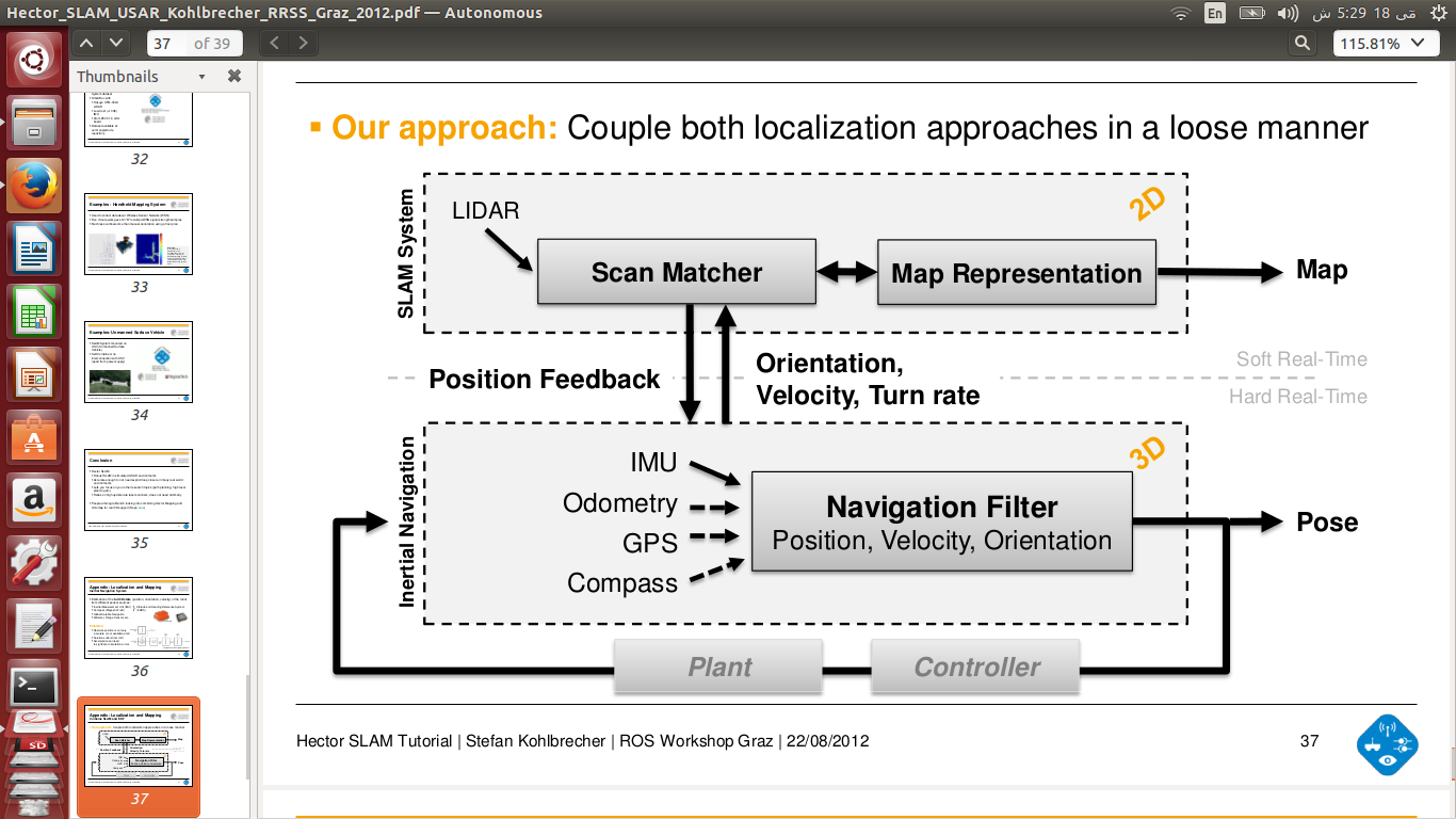
Hi @Stefan, i have successfully build a 3D map using hector_slam and octomaps and hector_localization. But there is just one issue which is after some time my robot looses its position and the map goes to infinity :P

hashim gravatar image hashim  ( 2016-05-18 07:22:40 -0500 )edit

As in you slides you have mentioned that localization and slam node must be loosely coupled and localization node must subscribe to imu, magnetometer, gps and poseupdate(from slam node) and must sent back the orientation, turn rate and velocity.

hashim gravatar image hashim  ( 2016-05-18 07:27:26 -0500 )edit

@Stefan the problem is here, how can i feed orientation, velocity and turn rate to scanmathcer ?

hashim gravatar image hashim  ( 2016-05-18 07:28:36 -0500 )edit

Added the photo above for reference

hashim gravatar image hashim  ( 2016-05-18 07:36:28 -0500 )edit

Question Tools

1 follower

Stats

Asked: 2016-01-13 03:36:51 -0500

Seen: 1,880 times

Last updated: May 18 '16